|
|
 |  | 
| Print this Brief |
| How might
climate change affect the coastal environment and coastal
communities? |
| |
Key Points
Climate change will affect the coastal environments of
the New York metropolitan region through sea-level rise
and its associated impacts, including more frequent storms
and flooding, higher rates of beach erosion, submergence
of coastal wetlands, and saltwater intrusion. These stressors
will put some coastal developments at increasing risk of
damage.
Storm Flooding
Scientists project an increase in the frequency of large
storms in the coming century (Table 1). At the same time,
sea-level rise would increase the area likely to be inundated
by these coastal storms because storm flooding would reach
higher inland elevations.
|
| |
Historical
Data
|
GCM Projections
|
|
1900 – 1997
|
2020s
|
2050s
|
2080s
|
|
Sea-level rise (inches)
|
+0.09 – 0.15
inches
|
4.3 – 11.7
in
|
6.9 – 23.7
in
|
9.5 – 42.5
in
|
|
+0.09 – 0.15
inches
|
10.9 – 29.7
cm
|
17.5 – 60.2
cm
|
24.1 – 108.0
cm
|
|
100-year flood zone
(feet)
|
9.7 feet
|
9.8 – 11.5
ft
|
10.1 – 12.4
ft
|
10.4 – 13.8
ft
|
|
3.0 meters
|
3.0 – 3.5
m
|
3.1 – 3.8
m
|
3.2 – 4.2
m
|
|
100-year flood return
(years)
|
Once per
100 years
|
80 – 43
yrs
|
68 – 19
yrs
|
60 – 4
yrs
|
|
| Table 1. Sea-level rise and
associated storm impacts |
Coastal storms striking the region are of two types: [1]
extratropical cyclones (“Nor’easters”)
and [2] hurricanes. Nor’easters are responsible for
major coastal flooding and beach erosion because they cover
a larger spatial area than hurricanes and often last longer,
so they take place over several tidal cycles at a particular
location. Nor’easters are also more common than hurricanes
in the New York metropolitan region.
 |
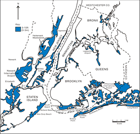
| Figure
1a. Areas at risk from a 10-foot flood.
Blue represents coastal areas vulnerable to
a flood that reaches a height of ten feet.
The likelihood of such a flood occurring is
increasing. Source: Gornitz,
Sea Level Rise and Coasts, in Climate Change
and a Global City, 2001. |
|
 |
 |
High population densities are presently concentrated
near the water’s edge at several locations throughout
the region and coastal populations are growing. Between
1960 and 1995, populations in coastal counties in New York,
New Jersey, and Connecticut grew by around 17%, with seven
coastal counties displaying growth rates exceeding 100%.
Because of the highly developed nature of the coast within
the region, a large population and considerable private
property and public infrastructure are potentially at risk
of hazardous
events (i.e. inundation and flooding) associated with sea-level
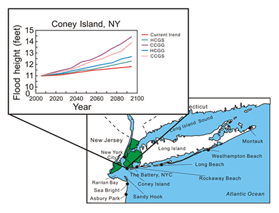
rise(Figures 1a and 1b). Land below five feet (1.5 meters),
such as Coney Island in New York City, could be permanently
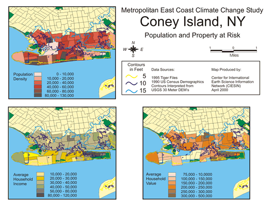
lost to inundation (Figure 2).Flood risk zones at coastal
sites cut across a wide range of income and housing values
(Figure 3).
 |
 |
 |
| Figure
1b. Westhampton property at risk of coastal
flooding. In this case, there is more land on which to rebuild the property than in most vulnerable locations in New York City. Source: Gornitz,
Sea Level Rise and Coasts, in Climate Change
and a Global City, 2001 |
|
 |
If population growth follows present trends, evacuation
of vulnerable populations in these high-risk areas during
major storms will pose serious problems because many evacuation
routes are close to flood-prone areas. Although permanently
lost land would occupy a relatively narrow coastal strip,
flooding due to storms could periodically engulf a much
greater area. Suburban and lower density sites such as
Westhampton, New York, or Sea Bright and Asbury Park, New
Jersey, have land-use characteristics that make zoning
setbacks and/or relocation to higher ground more feasible
than in
the intensively urbanized areas of New York City.
 |
 |
| Figure
2.Model projections for flood height at Coney
Island. Both the models project that sea level
will rise, but the Canadian Centre model (CCGG
and CCGS) predicts a greater increase than the Hadley Centre model
(HCGG and HCGS). Source: Gornitz,
Sea Level Rise and Coasts, in Climate Change
and a Global City, 2001. |
|
 |
 |
|
 |
 |
| Figure
3. Coney Island population and property at risk from flooding and sea-level rise. Source: Gornitz, Sea Level Rise and Coasts, in Climate Change
and a Global City, 2001. |
|
 |
|
Beach Erosion
Beaches are continually changing as sand is shifted by
waves, tides, and currents. Sea-level rise and land subsidence
contribute to beach erosion and the narrowing or movement
of barrier islands. With climate change, rates of beach
erosion would double or triple by the 2020s, increasing
three to six times by the 2050s, and four to ten times
by the 2080s, relative to the first decade of the twenty-first
century. Climate models project an increase in storms,
which would further contribute to beach erosion.
To compensate for losses from erosion, additional sand
would have to be placed on the beaches. Sand replacement,
also called beach nourishment, may remain a viable option
through mid-century, but could become significantly more
costly, particularly for the high-end warming scenarios,
by the end of the century.
 |
 |
 |
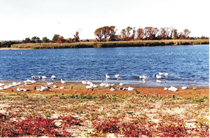
| Figure
4. Significant portions of Jamaica Bay
have been lost to rising waters. Source: Gornitz,
V., 2001 |
|
 |
Coastal Wetlands
Sea-level rise poses a significant
risk of additional losses to the already threatened coastal
wetlands in the region. Studies of selected salt-marsh islands
in the Jamaica Bay wetland indicate that they have lost roughly
12% of their total area since 1959, with sea-level rise a
possible causative factor. The rate of loss is projected
to exceed observed historical rates of salt-marsh accretion
and will disrupt current habitats of birds, fish and other
wildlife (Figure 4). Recreation areas located within wetlands
are also threatened by inundation.
Salt Water Intrusion
Another serious impact of rising sea level could be the
northward migration of saltwater up the Hudson River. The
salt front could reach the Chelsea Pump Station for a major
portion of the year. The Chelsea Pump Station provides
an emergency source of water for New York City during periods
of drought. Saltwater may also seep into Long Island aquifers,
compromising this critical water supply.
|
References:
Culliton, T.J. (1998) "Population: Distribution, Density,
and Growth." NOAA’s State of the Coast Report,
NOAA, Silver Spring, MD.
Gornitz, V. (2001) Sea-level rise and coasts. In Rosenzweig,
C. and W.D. Solecki, (eds.), "Climate Change and a
Global City: An Assessment of the Metropolitan East Coast
Region" (pp
21 – 46) Columbia Earth Institute, New York, 210 pp.
Rosenzweig, C. and W.D. Solecki (Eds.). 2001. "Climate
Change and a Global City: The
Potential Consequences of Climate Variability and Change – Metro
East Coast (MEC)." Report for the U.S. Global Change Research
Program, National Assessment of the Potential Consequences
of Climate Variability and Change for the United States,
Columbia Earth Institute, New York. 224 pp.
Related Resources:
Print version (factsheet
pdf)
|
|
 |
 |
| |
|
|
| |
|
|
|
File last modified: 29 March 2005 |
|
|
For more information about CIESIN and our activities contact CIESIN User Services
Telephone: 1 (845) 365-8988 - FAX:
1 (845) 365-8922
CIESIN is
a center within the Earth
Institute at Columbia University Copyright© 2004-2005. The Trustees of Columbia University in the City of New York.
|
 |
|
| |
|
|
|

